How Hurricanes Generate Waves
Waves form when sustained wind transfers energy to the ocean surface through friction and pressure gradients, and in a hurricane that process runs at full throttle. Three parameters control it: wind speed, the distance over which the wind blows (fetch), and how long the wind lasts.
Wind Fetch and Duration
Wave growth depends on wind strength, duration, fetch, and how the wave field moves relative to the storm. Faster motion can extend the effective fetch for waves traveling with the storm, so slower does not always mean higher waves.
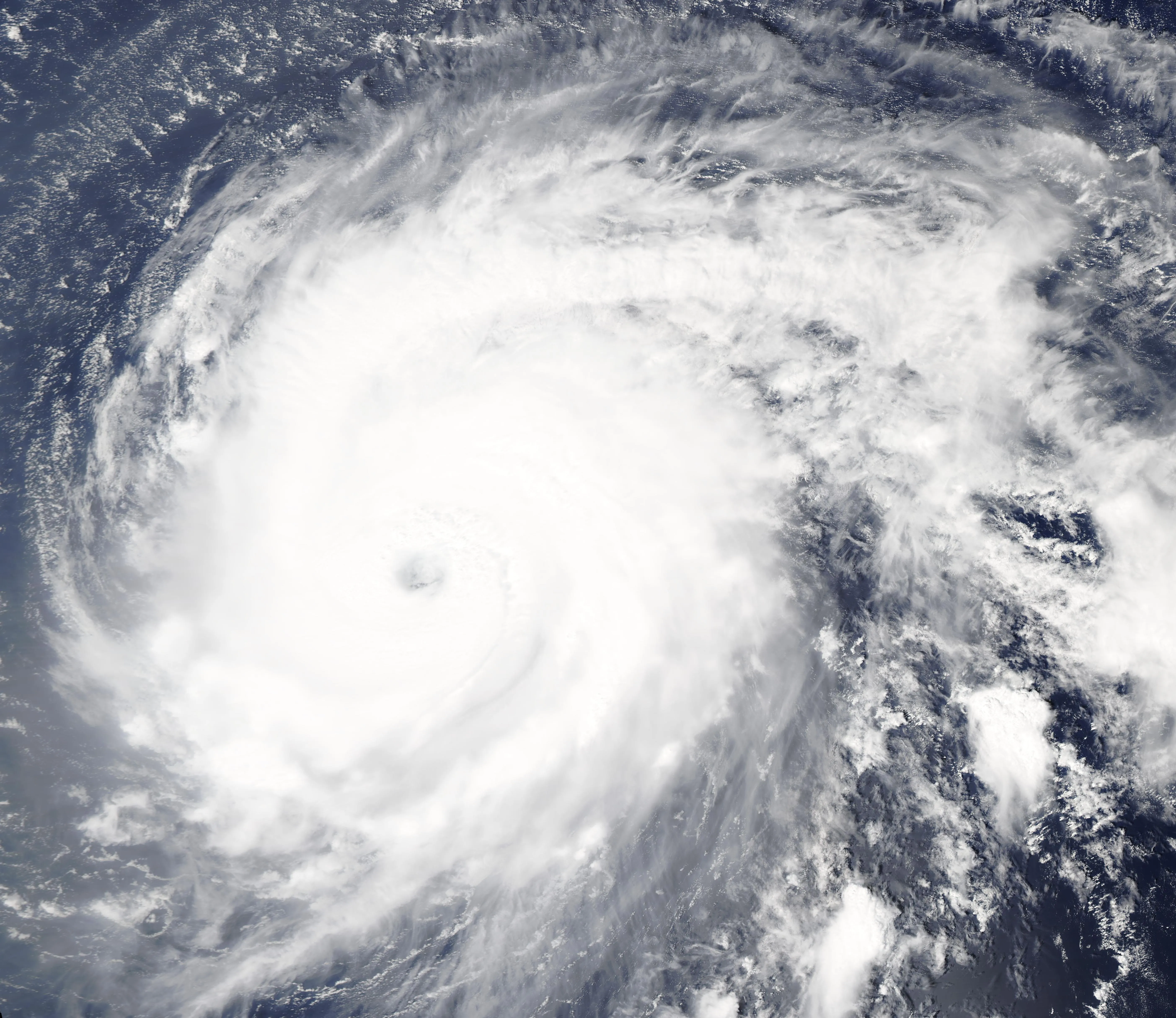
Asymmetric Wave Generation
In the right-front quadrant of a hurricane (in the Northern Hemisphere), the storm's forward motion adds to the wind speed and builds the strongest waves; the left-rear quadrant sees the weakest. That asymmetry is a big part of why coastal impacts run most severe on the right side of a landfalling storm's track.
Wave Heights in Hurricanes
Significant wave height describes the average of the highest third of waves, or a closely related spectral estimate. Individual waves can be substantially higher. Offshore maxima should not be treated as typical breaking-wave heights at a beach.
Extreme Waves and Rogue Waves
In Ivan, researchers measured a maximum significant wave height of about 17.9 m (59 feet) and an individual crest-to-trough wave of 27.7 m (91 feet). An extreme individual wave is not automatically a rogue wave; that classification depends on its height relative to the surrounding sea state.1
Waves transform through shoaling, refraction and breaking as they approach shore. Breaking height depends on depth and coastal geometry; there is no universal 20–40-foot range for waves that damage coastal buildings.
Swell Propagation
Swell can travel long distances. In deep water, group speed depends on wave period, so there is no single hurricane-swell propagation speed. Dangerous surf can arrive long before the storm center.
Waves Riding the Surge
Surge raises the water level on which waves act. Breaking waves can raise mean nearshore water level (setup) and drive intermittent uprush on the shore (runup). Their contribution depends on the site.
Wave Setup and Runup
Wave setup is the increase in mean water level caused by changes in wave momentum flux near shore. Runup describes the vertical reach of wave uprush; some runup definitions include setup. Check definitions before adding components.2
Total Water Level
A shoreline total-water-level estimate combines tide, meteorological water level, and a defined wave contribution. Adding both setup and a runup measure that already includes setup double-counts it. State the vertical datum and chosen runup statistic.2
Coastal Erosion During Hurricanes
Storms can erode beaches and dunes rapidly. Recovery depends on sediment supply, subsequent waves, sea level and interventions; it does not follow a universal five-to-ten-year schedule.
Beach and Dune Profile Changes
Storm waves can erode the beach and dune toe and move sediment offshore, alongshore or landward. The magnitude varies by site, so fixed “routine” retreat and lowering ranges are misleading.3
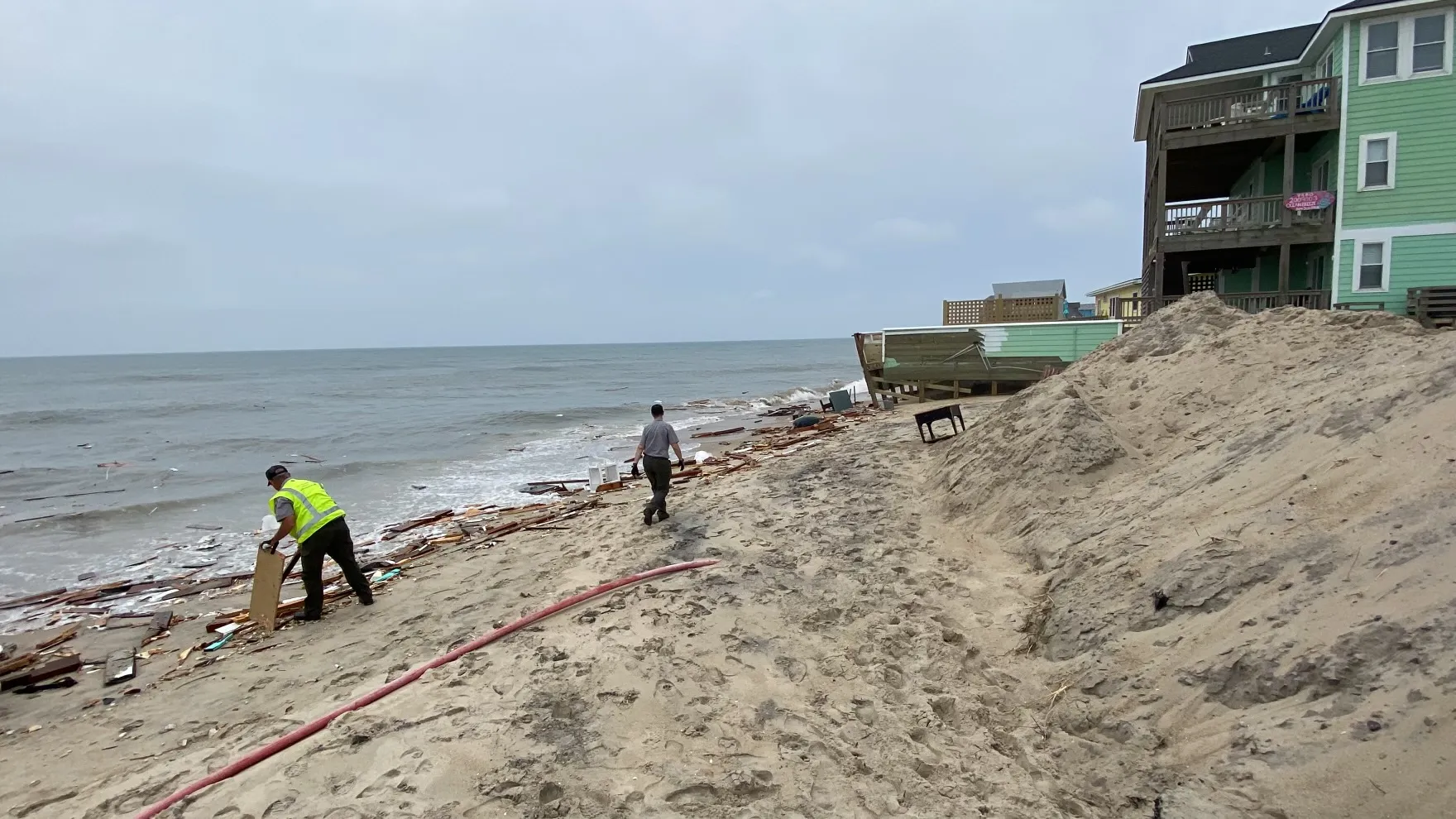
Overwash and Barrier Island Breaching
Overwash occurs when waves cross a dune or barrier crest and carry water and sediment inland. Sustained inundation and currents can open a breach, but some breaches close naturally or through management; they are not necessarily permanent.3
Alongshore and Cross-Shore Transport
Hurricane-driven currents move sand hundreds to thousands of meters. Rip currents, seaward-flowing jets driven by wave setup, drag sandbars offshore, while alongshore currents from oblique wave approach shift sand parallel to the coast, sometimes building one beach while catastrophically eroding its neighbor. This transport runs during the storm and keeps going for weeks after the system leaves.
Barrier Islands and Coastal Inlets
Barrier islands, the elongated sand bodies between the mainland and the open ocean, shield bays, estuaries, and towns from the sea. They're also the most dynamic features on the coast, and hurricanes remake them fundamentally.
Historical Changes
The Chandeleur Islands have experienced severe storm-driven erosion, including during Katrina, alongside longer-term subsidence, relative sea-level rise and sediment changes. A single acreage or recovery claim needs a dated survey boundary.3
Inlet Formation and Migration
New inlets from hurricane overwash often persist for years or decades. Hatteras Inlet in North Carolina, which sits where it does because of a hurricane-driven breach in 1846, has migrated substantially since. Storm currents favor migration at first; over time, tidal currents can either stabilize the inlet or let it close if the barrier reforms.
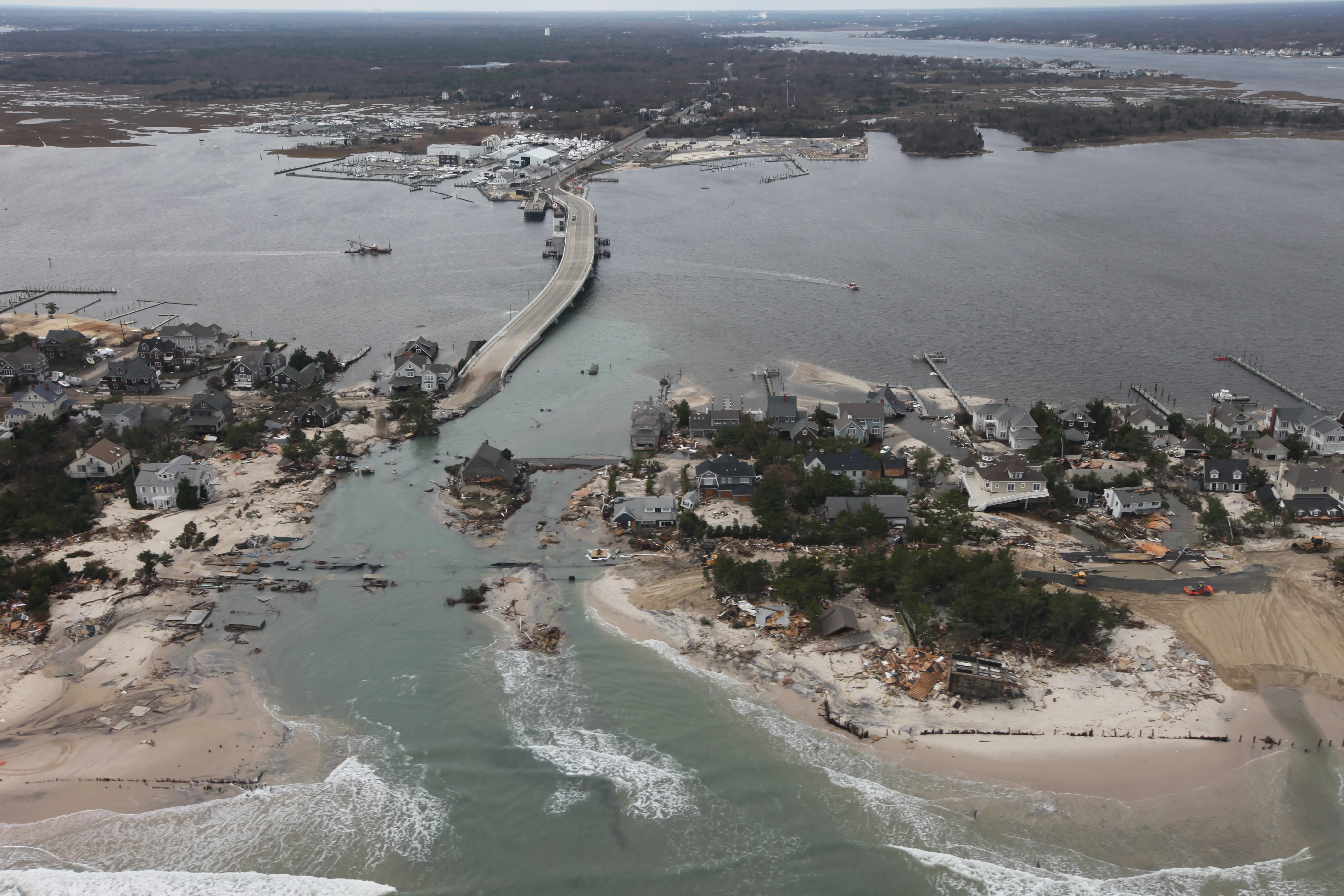
Long-Term Coastal Change
A single hurricane's coastal impact is dramatic, but it's the cumulative effect of repeated storms over decades that shapes an entire coastal system. The Gulf Coast, the Atlantic seaboard, and the Caribbean have all seen significant net erosion and shoreline retreat over the past century, driven by both storms and rising seas.
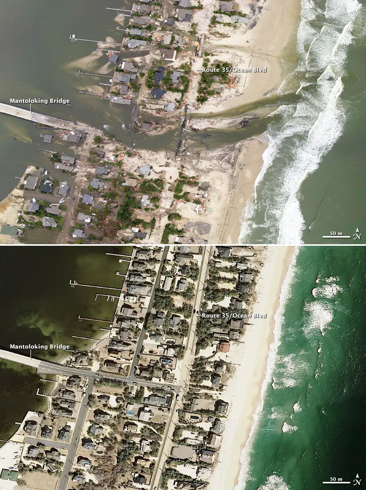
That night on the New Jersey shore was Hurricane Sandy, 2012.
Sediment Budget Deficits
Recovery depends on the sediment budget and where transported sand remains accessible to the beach. River engineering, dredging, structures, storms and relative sea-level change can alter that budget. The Mississippi delta is not an example of assured recovery merely because the river carries sediment.
Sea Level Rise Acceleration
Sea-level trends require a stated location and measurement period. NOAA tide-gauge trends measure relative sea level, including local land motion. Do not add subsidence again to a relative trend, or convert a rise into a new flood return period without a local analysis.4
Retreat vs. Armoring
Coastal communities face a hard choice: retreat from an eroding shoreline and let natural processes run, or armor the coast with seawalls, bulkheads, and jetties. Here's the uncomfortable engineering truth, and we'd rather say it plainly: you can't armor your way out of a sediment deficit and a rising sea indefinitely. A seawall buys time and, more often than not, exports the erosion to the beach next door while starving its own of sand. Managed retreat, buying out the most vulnerable property and restoring natural features, is increasingly recognized as the more sustainable answer, and it's also the one that's hardest to do, economically and politically.
Building Codes and Coastal Construction
After each devastating hurricane, building codes have evolved to reflect a better grasp of coastal wave and surge hazards. The central regulatory tool is the FEMA Flood Hazard Map, which sets the flood-risk zones and the building requirements that go with them. (For the whole-house picture, see how to hurricane-proof a home.)
V-Zones and Wave Velocity
Coastal V zones are associated with the 1% annual-chance flood and significant wave hazards, generally waves at least 3 feet high. The coastal BFE includes modeled wave effects; it is not a fixed 1.5-foot allowance. NFIP rules use the elevation of the bottom of the lowest horizontal structural member, and locally adopted requirements may add freeboard.2
Pile Foundations and Breakaway Walls
Open foundations must be designed for the applicable coastal loads. Permitted enclosures below the elevated building require appropriate breakaway construction and are restricted to uses such as parking, access and storage; they are not a sacrificial occupied first floor. Breakaway walls are not limited to the seaward side.2
Setback and Erosion-Hazard Zones
Coastal setbacks and development restrictions vary by state and locality, structure size, shoreline type and erosion rate. Consult the relevant coastal permitting authority for a specific property.
Sources
-
Wang, D. W., Mitchell, D. A., Teague, W. J., Jarosz, E., & Hulbert, M. S. (2005). Extreme waves under Hurricane Ivan. Science, 309(5736), 896. https://doi.org/10.1126/science.1112509 ↩
-
Federal Emergency Management Agency. (2011). Coastal Construction Manual (FEMA P-55, 4th ed.). https://www.fema.gov/emergency-managers/risk-management/building-science ↩ ↩2 ↩3 ↩4
-
U.S. Geological Survey. Coastal Change Hazards. https://www.usgs.gov/programs/cmhrp/science/coastal-change-hazards ↩ ↩2 ↩3
-
National Oceanic and Atmospheric Administration. Sea Level Trends. NOAA Tides & Currents. https://tidesandcurrents.noaa.gov/sltrends/ ↩